A.
A map is a representation or a drawing of the total or a part of earth's surface drawn on the surface according to a scale.
Maps are many types. They are political maps, physical maps, thematic maps, weather maps, railway route maps and population maps etc.
*Hang a political map of India in the class. Look at the map carefully and answer
the following questions:
i. Mehar went to Bhopal from Hyderabad. In which direction did he travel?
A.
Mehar went to Bhopal from Hyderabad in the North direction.
ii. Ashok went to Chennai from Lucknow. In which direction did he travel?
A.
Ashok went to Chennai from Lucknow in the South direction.
iii. Regina went to Bhubaneshwar from Mumbai. In which direction did she
travel?
A.
Regina went to Bhubaneswar from Mumbai to Bhubaneswar in the East direction.
iv. Weprechu went to Jaipur from Kohima. In which direction did he travel?
A.
Weprechu went to Jaipur from Kohima in the West direction.
*What is called Atlas?
A.
Atlas is a book with collection of maps. It was named after King Atlas, a mythical King of Mauretania in Libya.
*Write about the contour lines ?
1. A contour is a line joining the places with equal heights on the map.
2. All places on this line will have the same height.
3. Contour lines are shown in irregular shapes, distance between two contour lines will depending upon the land form.
4. These lines can't cut with each other.
5. If the land has a steep climb, then lines will be near to each other.
6. If the slope of the land is gentle, lines will be quite far from each other.
*What is called Physical Maps?
A.
Maps showing natural features of the earth such as mountains, plateaus, plains, rivers and oceans.
*What are the uses of maps showing heights?
A.
1. These maps help us to understand the nature of the terrain, where the mountains are, where the valleys are etc.
2. Maps showing heights are very essential when roads or dams have to be constructed.
3. If we have to lay roads in an undulating region between two places, such maps help us in deciding the route to be taken by the road.
4.Similarly, when dams are planned it is necessary to know how much land will be submerged by the water of the dam.
*What do you understand Scale?
A.
Scale is the ratio between actual distance on the ground and the distance shown on the map.
*Why are the levels of all the seas equal in the world?
A.
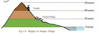
1.All heights are on the land calculated from the sea level.
2.All seas in the world are connected to each other, more or less the sea level (surface of sea) all over the world is taken to be roughly the same.
3.The temple is 100 meters high above the sea level. The top of the hill is 150 meters high from the sea level.
4.Thus we can say the levels of all the seas are equal in the world.
*What do you mean Mean Sea Level
?
A.
1. The level of the sea keeps on either rising or falling due to high tides and low tides.
2. The level of the sea is carefully measured at frequent intervals and the mean level of the sea is calculated.
3. Over a period, scientists observed the high and low levels of the sea and they have come to one calculated average level, which is known as Mean Sea Level (M.S.L.)
*What do you mean Political Maps?
A.
Maps showing cities, towns and villages and different countries and states of the world with their boundaries.
*What differences do you find between the life style of people living on high altitudes and low altitudes?
A.
Difference between the people living on the high and low altitudes:
People of High Altitudes:
1. They live in mountainous regions.
2. They are economically backward.
3. They wear woollen clothes.
4. They enjoy insecured life.
People of Low Altitudes:
1. They live in plains.
2. They are economically well developed.
3. They wear cotton and silk clothes.
4. They enjoy secured life.
*How is the sea level measured?
A.
1.The level of the sea keeps changing.
2.The level of the sea is carefully measured at frequent intervals and the mean level of the sea is calculated.
3.Tidal gauge is used to measure the rising and falling of the sea.
*What do you understand Thematic Maps?
A.
Maps representing a particular topic or theme


